http://www.dispersedcampgrounds.comhttp://www.eugenecarsey.com

Free camping and campgrounds
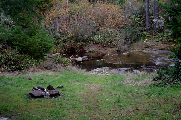
OREGON CAMPGROUND DIRECTORY
WEST FORK SMITH RIVER ROAD
Dispersed and Primitive Camping

West Fork Road Waterfalls

LATITUDE: N 43.50.300
LONGITUDE: W 123.44.945
(GPS from above campsite and panorama image)

There are limited side roads and hideouts,
but if you keep an open eye, you'll find
somewhere nice to camp. There are very
few people or cars...

Camp
West Fork Smith River
N 43.50.300
W 123.44.945

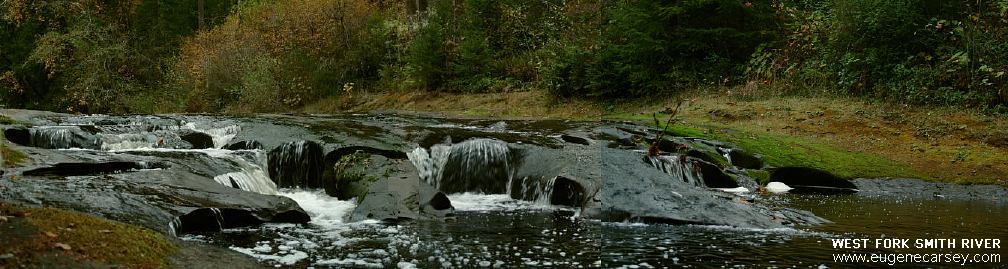
This camp and above waterfall photos
are on the West Fork Smith River Road,
4 miles north from Smith River Road.

Smith River Road
Smith River Road

Smith River Road
Smith River Road

Raspberries, blackberries, and boysenberries
are in abundant supply during harvest season.

DIRECTIONS:
From Eugene, take Hwy 126 to Crow Road
(at Shell Station just outside of town).
Take Crow Road to Smith River Road.

Also from Eugene, you can take Hwy 136 to Veneta.
Turn left at Territorial Hwy about 2 miles past Crow.
Turn right on Wolf Creek Road(#4078).
From here follow the signs.

From Florence
Take Hwy.126 East
Turn on Siuslaw Road
(Between milepost 26-27)

From Reedsport...
Hwy.38 to Wells Creek
Turn left at Wells Creek Road ...

From Reedsport / Gardiner
Go towards Sulfur Springs...

From Cottage Grove...

From Sutherlin / I-5 at Exit 136
Take Hwy.138 to Elkton
Take Hwy.38 west towards Florence
At Wells Creek take Wells Creek Road
15 miles to Vincent Picnic...
Lots of Blackberries on Wells Creek Road.

We've been here a couple times and there was always
one road that was blocked. This time there was a tree
across the road before Kentucky Falls.
UPDATE:
The road between Whittaker Campground and
Kentucky Falls has been blocked with truck
loads of dirt.

When FIRE RESTRICTIONS are in effect,
all vehicles are required to carry:
- 1 gallon of water or 2 1/2 lb. fire extinguisher
- Shovel with 8" blade at least 26 inches long
Carrying an ax is recommended
A pair of leather gloves are good idea.

Water at Clay Creek BLM Recreation Site.
Most of the established BLM Recreation Sites
have fee campgrounds with drinking water.

Showers in Florence at the laundry...
Curves Laundromat
$2.00 in Quarters / 8 minutes
37th Street Laundry
$xx for xx minutes

DEAN CREEK ELK VIEWING AREA
Highway 38 a couple miles east from Reedsport
Never actually saw any elk here...

ESTABLISHED CAMPGROUNDS
CLAY CREEK BLM RECREATION SITE
FAWN CREEK BLM RECREATION SITE
VINCENT CREEK RECREATION SITE
Didn't see any fees, but it was crowded this day.
Outhouse, garbage...
Located at the Jct. of Vincent Creek Road 20-9-33.0
and Smith River Road 20-11-36.0
(14 miles to Sulfur Springs)
WHITTAKER CREEK BLM RECREATION SITE
$10.00 / Free day Use
(No dogs allowed in Day Use Area)

ARCHIE KNOWLES CAMPGROUND $15.00
Siuslaw National Forest
Highway 126 between milepost 17-18
Strict rules about dogs

WILD CAT BRIDGE(Covered Bridge)
Built 1925
AUSTA BOAT RAMP
LANE COUNTY PARK
As you turn on Siuslaw Road from Hwy.126,
there is a sharp curve. Stay to the right towards
Austa boat ramp and you will see Wild Cat Bridge.
Worth some photos. Continue down the roads and
there are possible camps and overnight parking.
Blackberries cover the hillside.

Also see: SMITH RIVER FALLS
Also see:
VINCENT CREEK

CAMPGROUND INDEX
Complete free campground listing

CAMPING ADVICE AND TIPS

TOURIST PHOTOS

Google Custom Map Free Oregon Campgrounds
Google Custom Map by Ian

OREGON FREE CAMPGROUND MAP
Google custom map by Ian with most of the
free campgrounds in Oregon
.

Camped here October 22, 2005
Camped here July 26, 2006

Copyright Notice
www.eugenecarsey.com

dispersedcampgrounds.com
Free campgrounds and camping
OREGON CAMPING
SMITH RIVER
WEST FORK SMITH RIVER ROAD